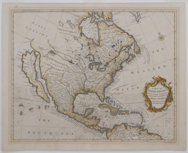
Description
Depicts North America, divided into several regions including California, New Mexico, New Britain, Nova Scotia, Florida, Louisiana and Florida. Mexico and Central America are divided into several regions including Apacheria, New Leon, Culiacan, New Biscay, Gallicia, Guasteca, Panuco, Mechoachan, Xalisco, Mexico, Tlascala, Guaxaca, Tabasco, Vera Pax, Guatimala, Honduras, Nicaragua, Jucaton, Co. Rica and Darien. Also shown are the Caribbean Islands, Cuba, the Bahamas, Jamaica, and the northern part of South America. The eastern coast of North America shows the British Colonies including South Carolina, North Carolina, Virginia, Maryland, Pennsylvania, New York, and New England. Of note, California is shown as an island with the body of water separating California from North America as the Gulf of California or Red Sea. Northern California is labelled as New Albion and contains a mountain chain with one mountain on the northwest California coast labelled as “Mt. St. Martin.” In the Gulf of Mexico and in the Atlantic Ocean the routes of Spanish Galleons, the Armada and the “Flota” are shown. Areas inhabited by the North American Indian tribes are labelled including territory occupied by the Cherokee and the Apache’s. Shows detailed river and place names including the Mississippi River, the Great Lakes, the St. Lawrence Seaway and Hudson’s Bay. Also depicts mountains in the west in an area labelled as Great Teguaio and in “Parts Unknown.” Shows compass rose in upper right. The title cartouche is adorned with flowers and ornate decoration.
Published in Rapin’s “The History of England,” volume 15, translated by Nicolas Tindal. According to Wheat, despite its late publication date, the map continues to display several “throwback notions” of North American geography. For instance, the map follows the geography from apocryphal accounts by Baron Louis-Armand de Lom D’Arce de Lahontan in the late seventeenth century. Moreover, California is shown as an island (Wheat, 70-1). Within California, a mountain chain is shown and two mountains are labelled: M. Nevada and Mt. St. Martin. Six towns are also labelled in California including Canot, St. Nicholas, St. Juan, St. Isidore, Gigante and Na Sa de la Guada (Tooley, “California as an Island,” 134, entry 97).